


Sri Lanka has the beaches for relaxation. Sri Lanka has the heritage sites for round tours. But Sri Lanka also the highlands, famous for tea, but also a hotspot of biodiverstity, wonderful for hikes, but also rich in culture.
|
Our overview focuses on four quite diverse holiday regions in Sri Lanka's hillcountry. The northern part around Kandy is in moderate altitudes and dominated by the Mahaweli River. Touristic highlights in this region include lots of cultural attractions such as handicraft and temples and religious festivals. The most interesting destinations for nature lovers are the nation's largest Botanical Gardens and bird watching area close to Kandy town and, last not least, Sri Lanka's best trekking area, known by its English name Knuckles Range. The western ridge of the hillcountry is the best destination for those who are looking for more demanding holiday adventures. The Kitulgala river valley has the best rafting and canyoning and jungle walk options, whereas Adam's Peak can be reached only via the longest flight of stairs. The surroundings are densely forested and not easy to explore. In contrast, the central part of the highlands, though in even higher altitudes, allows quite comfortable journeys, almost the entire area in altituted up to 2000 m being covered with tea plantations. Slightly uphill to the southwest is the Uva Basin, surrounded by various ridges. The Uva Hills are a perfect holiday region for a mix of easy hikes and tea plantation visits and is most famous for its panoramic views. Let's start with Kandy, the largest town in the hillcountry.
|
Nuwara Eliya in the Cental Highlands is Sri Lanka's highest town
|
Kandy & Knuckles - cultural heartland & Trekking Region
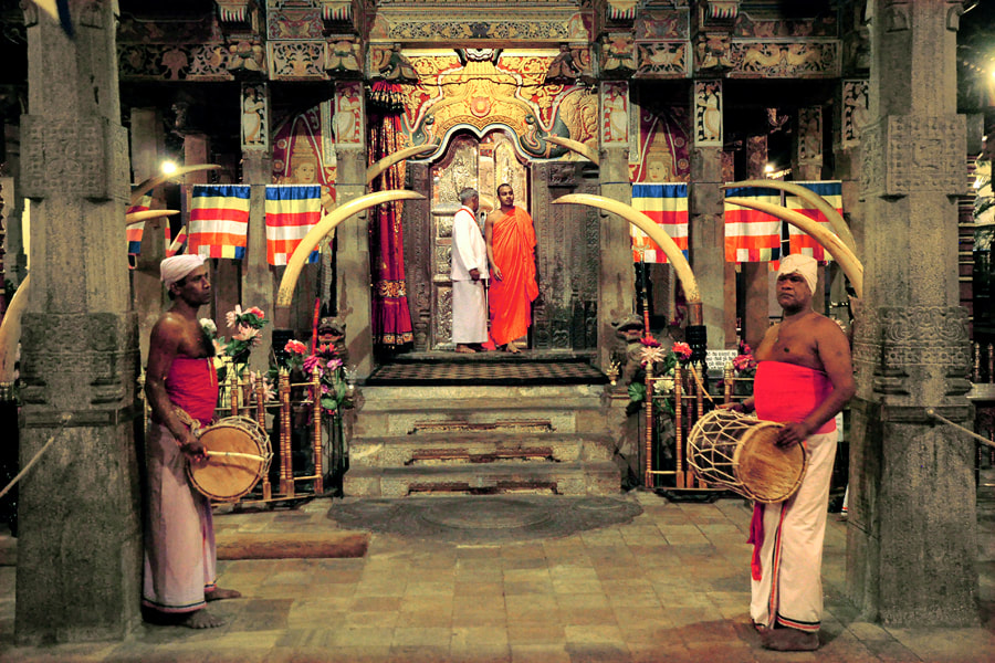
Kandy is known as the hill capital of Sri Lanka and a centre of Sinhalese culture. Due to its secluded location in the hillcountry, Kandy was able to maintain independence from Portuguese and Dutch rule over the coastal plains, until it fell to the British in 1815. The long tradtion of independence and resistence is one reason why the Buddhist culture of the Sinhalese people has remained authentic in this region. Tourists should not miss to visit a ceremony such as the daily Pujas at the Tooth Temple and also attend a Cultureal show and visit one of the museums. Kandy's major attractions are three kinds of religious heritage sites.
Firstly, there is the world-famous Temple of the Sacred Tooth, the most revered relic in Buddhism, attracting pilgrims not only from all over the island but also from other Buddhist nations. Secondly, the head monasteries of the two branches of Sri Lanka's largest Buddhist order are in Kandy. Of these, the Malwatta monastery, at the southern shore of the Kandy Lake, just at the oppostite side of the Tooth Templem is most notable for its ceremonial hall and the museum that was established in former monk's cells, which were built in a traditional style. Thirdly, there are four so-called Devales close to the Tooth Temple. They are dedicated to the four major deities protecting the island. Remarkably, the Hindu gods are venerated by Buddhists, too. Actually, three of the temples have Sinhalese priests, whereas the Kataragama Devale, a little bit farer away from the Tooth Temple but just in the centre of the market areas of the town, has Brahmin priests who are Tamils. Nevertheless, a Buddhist shrine is attached to the Kataragama Devale and it is frequently visited by Sinhalese, too. The temples of the Tamil minority are not called Devales but Kovils. Apart from temples, there are also several mosques and churches in Kandy.

Kandy Tooth Temple by night
|

Puja in the Tooth Temple
|
Tooth Temple ground floor
|
Visitors of Kandy should visit one of the view points to Kandy Lake. Senani view point is most popular, as it allows to see the Gilded Roof of the Tooth Temple at the opposite side of the lake. Kandy is a centre of handicraft and perfect for shopping, there are local markets of various kinds as well as exhibition halls of products for international guests. For those who are not specialists but interested in purchasing one or two of the island's famous gemstone, just as a souvenir or to make use of the opportunity, gem shopping in Kandy's large and renowned jewellery stores is safer than small shops or street traders anywhere else for being informed honestly and correctly about the characteristics and the value of each specific gemstone.

Udawattakale view to Kandy Lake
|

|
Peradeniya is a suburb of Kandy and has one of the two most renowned universities of the nation. Actually, Peradeniya is the only town in Sri Lanka that's a university city in the first place. Travelers visit Peradeniya for the world-famous Royal Botanical Garden, the beginnings of which date back to the era of Kandyan kings, but the park was established as a scientific arboretum and collection of flower species from all over the world by the British. It's location in a river loop and the avenues and lawns contribute to the beauty of the park.

Vijayotpaya stupa in Gadaladeniya
|

Buddhist shrine in Lankatilaka
|

woodcarving in Embekke
|
For lovers of ancient art and architecture, the surroundings of Kandy are crowded with late medieval and early modern temples. The most noteworthy and also most visited ones are the three so-called "Western Temples", located to the west and southwest of Peradeniya. They are from the late medieval Gampola period, each of them combines Buddhist and Hindu shrine but in different ways. And each has characteristics of its own. Gadaladeniya has remarkable door paintings from the 13th century. In Lankatilaka the entire shrine room is decorated with classical Kandyan paintings from the 18th century, Embekke has the best woodcarvings you can find anywhere in Sri Lanka.

Tampita temple architecture in Danthure
|

Natha temple in Dodanwela
|
There are some less-known temples, admittedly less exciting than those mentioned above, to the northwest of Kandy, namely the numerous small shrines in Danthure and Dodanwela, which are entirely in the typical style of the Kandyan period.

Degaldoruwa murals depicting Jatakas
|

Dvarapala statues in Hanguranketa
|
To the east of Kandy are some less-visited temples that would deserve more attention indeed. The cave temple of Degaldoruwa is one of the best places to see Kandy paintings, murals depicting scenes from the life and the previous lives of the Buddha. They are rich in details and second in quality only to those of World Heritage Site Dambulla. 30 km further southwest is the temple of Hanguranketa. It also has lots of Kandyan paintings, but they are from the 19th century, as this temple, once burnt down, was rebuilt completely during the British colonial period. With a veranda around the entire image house, the style is colonial indeed. However, the Hanguranketa temple is definitely worth visiting due to the large collection of Ola leaf manuscripts that are kept in the museum, which is in the upper storey of the large gatehouse.

Corbett's Gap in Knuckles Range
|

view from Deanston Mini World's End
|
Knuckles Range to the north of the large reservoirs in the Mahaweli river valley is a perfect hiking destination in the first place, but it also has several routes for multi-day trekking with camping. Several of the highest hills can be climbed without any mountaneering skills. The region is also rich in waterfalls. The most popular starting points are Meemure in the centre of Knuckles Range and Riverston in the northern foothills. However, there are many routes that are less known. Knuckles Range is also worth considering a detour for those who do not like to walk many hours. The trail to the spectacular escarpment called Mini World's End near Deanston is only 1.5 km long up and down together.
Western Highlands - From Adam's Peak to Kitugala
The western ridge of the hillcountry forms the border between the Central Province and Sabaragamuwa Province. Only one road passes the hills to the south of Kadugannawa at the Colombo-Kandy roads, namely a section of the A7 Colombo to Nuwara Eliya Eliya road, it crosses the entire Kitulgala Valley from Avissawela to Ginigathena pass. This valley of the upper reaches of the Kelani River is Sri Lanka's adventure destination number one. Apart from relaxing activities such as canoeing and birdwatching, this area offers the best white water experience on the island, with rapids of grade 3 and 4 out of 5. Canyoning and waterfall abseiling are also on offer. The Kitugala Valley is a hiking area, too. Several waterfalls are hidden in the jungles and rarely visited, most notably the Upper and Lower Falls of Mannakethi.

Kelani river valley near Kitulgala
|

white water rafting in Kitulgala
|

canyoning near Kitulgala
|
Situated 6 km uphill from Kitulgala in a secondary valley, the Beli Lena cave is special in many respects. Firstly, it's deeper cut into the rocks than most other so-called "caves" in Sri Lanka, which are actually rock shelters or abris. Secondly, the opening of the largest cave is covered by a waterfall after heavy precipitation. Thirdly, Beli Lena is one of the most significant prehistoric caves in Sri Lanka, a finding place of artefacts and skeletal remains of the so-called Balangoda culture.

Lower Mannakethi Falls
|

Beli Lena
|
The more famous waterfalls are Aberdeen and Lakshapana on the way from Kitulgala to Adam's Peak via Norton's Bridge. Both waterfalls require to climb a flight of steps downwards to their respective pools (and upwards again). Though mentioned in many pocket guides, they are still very charming places allowing you to avoid the crowds.

Aberdeen Falls
|

Lakshapana Falls
|
The greatest attraction of the western ridge, of course, is Sri Lanka's iconic and sacred mountain known as Siri Pada to locals and Adam's Peak to the rest of the world. It's a major pilgrimage site for four world religions, the ceremonies at the temple on the summit are Buddhist and Hindu. Adam's Peak can be rached via two different flights of stairs. It takes around 6000 steps along the classic pilgrimage route from Ratnapura in the lowlands. The more comfortable climb is from the Hatton side, starting in Nallathanniya, formerly known as Dalhousi, it's "only" 4800 steps to the top. But it's definitely worth it. The summit of Sri Lanka' "Matterhorn" is by far the best viewpoint and sunrise point on the entire island. Good weather conditions provided, you can see the triangle shadow of the conic peak in the western plains during the hour after sunrise. As this is the best time for views and also the most holy hour for rituals, most visitors start the 2 to 4 hours climb in the night to be on the top in time. Actually, you can manage to reach the summit within only two hours, if you don't take a break. But it's really recommendable to sit down for a cup of tea at one of the many stalls along the stairway several times, then the climb is less exhausting but needs more time. The entire flight of stairs is lit in the night during pilgrimage season from December till May. Be aware, that the stairs can be crowded and even overcroweded - one single cew - at fullmoon nights, particularly if the fullmoon or Poya days, which are bank holidays in Sri Lanka, fall in Fridays or Mondays.

triangle shadow of Adam's Peak
|

view from Adam's Peak to the Central Highlands
|
Tea Highland Train
special attraction in Sri Lanka's central highlands is a train raid, offering a relaxed way to enjoy some pleasant views to the tea plantations and exciting panoramas of the mountains at the same time. The most scenic part of the highland railay line in this respect is the section between Hatton and Nanu Oya station near Nuwara Eliya. For those traveling from Adam's Peak to Nuwara Eliya or Horton Plains it's definitely worth considering to take the train. But also the section between Nanu Oya and Ella is highly recommendable. But you should be aware that this part is of a different character. The great panoramas are only close to Nanu Oya, the hills covered with tea are between Haputale and Ella. The highest part of the ride in an altitude of almost 2000 m above sea level crosses the so-called "High Plains", which are mainly a vegetable cultivation area. The descent from here to Haputale crosses dozens of tunnels in at the forested slopes of the Horton Plains range, with some openings allowing views to the wide Uva Basin.
Central Highlands - Nuwara Eliya & Major Tea Regions
Nuwara Eliya is the highest city in Sri Lanka. It was founded by no less than Samuel Baker, who later on became famous as an explorer in Africa. Originally a colonial farming project, Nuwara Eliya soon developed into a classical British hill station, attracting families of colonial officers from Colombo during the hottest season of the year in the plains, mainly April and May prior to the monsoon season. The British established a turf and a golf course and several clubs. It's due to the British flair and the colonial architecture that Nuwara Eliya earned the nickname "Little England". The cool climate turned out to be perfect to cultivate European vegetables, potatoe cabbage cultivation is predominant in the valley, wherea tea cultivation is mainly found at a slightly lower altititude.

Nuwara Eliya town
|

Nuwara Eliya tea region
|
Nuwara Eliya is surrounded by the three highland tea regions of Sri Lanka, namely Nuwara Eliya in between the city of the same name and Kandy, Uda Pussalawa to the east and Dimbula - the largest tea growing area on the island - to the west, whereas Kandy and Uva plantations are in intermediate altitudes and Sabaragamuwa and Ruhuna are mainly lowland tea regions. The road from Kandy to Nuwara Eliya crosses the Nuwara Eliya tea region, where several waterfalls such as Ramboda and three major tea factories are open to the public, viz. Glenloch, Bluefield and Damro formerly known as Labookellie. Dimbula stretches from Nuwara Eliya till Adam's Peak. Tea factories can be visited near the waterfalls of Devon and St. Clair's, which are on the way via Hatton to Kitulgala. Uda Pussalawa is only a small tea region and not frequented by busloads.

Ramboda Falls
|

St Clair's Falls
|

Devon Falls
|
Close to Nuwara Eliya are Gregory Lake and Sita Eliya, which has become the most important Ramayana pilgrimage site for Hindo devotees, and Hakgala, Sri Lanka's highest Botanical Garden. The latter is also known as one of the best places to observe the highland avifauna.

view from Horton Plains to Adam's Peak
|

view from Horton Plains to Sinharaja
|
Nuwara Eliya is the best starting point to explore Horton Plains. Excursions usually start already before sunrise, because it takes one hour for only 30 km driving or even longer in case of cews at the ticket booth of Horton Plains National Park. The hike from the central car park to Big World's End takes another 2 hours and the plains get foggy around 10.00 am or even earlier. Hence, if you want to enjoy the views, you should start from Nuwara Eliya prior to 6.00 am in the morning. The 3 to 4 hours hike on the most popular trail, which also runs along Bakers Falls, is highly recommendable for first-time visitors of Sri Lanka's highlands. The scenery and vergetation are very diversified along this standard route.
Uva Hills - The charming southeast of the Hillcountry
Uva is a province situated partly in the hillcountry and partly in the southeastern lowlands. Most of Badulla District is situated in the southestern parts of the highlands, forming the so-called Uva Basin, which is framed by the so-called "High Plains" near Nuwara Eliya in the west, the Uda Pussalawa Range in the north and the Eastern Platform of the so-called Southern Wall of the Higlands to the south and the Lunugala Ridges to the east. The southern part of the Uva Basin is the famous Uva Tea Region which was largely developed by Thomas Lipton. It's this chain of hills in moderate heights situated between two 2000 m high mountanous regions of Horton Plains and Namunukula that is most interesting for travelers. The four accommodation hubs in the Uva Tea Region, from west to east are Haputale, Bandarawela, Ella, and Badulla. Haputale and Ella have smaller hotels and plenty of guesthouses, whereas Bandarawela has fewer but larger hotels. Badulla is much less frequented by foreigners and has a few budget accommodations mainly for independent travelers.

Uva Basin with Namunukula Mountain
|

Haputale view to Horton Plains
|
Haputale, not far from Horton Plains, is clinging precipitously to both sides of a razor sharp ridge, which at an elevation of 1431 m aboce sea level is also one of the two major passes from Uva Basin to the southern plains, Ella being the other pass further east. Haputale is famous for its two very diverse panoramic views, namely to the highlands in the north and to the plains in the south. The best vantage point to see both of them at once is Lipton Seat alias Lipton Point 16 km further east, named after the famous founder of the tea company, whose favourite resting spot it was indeed. In between Lipton Point and Haputale is the Dambatenne Tea Factory, which was the one Thomas Lipton established first. Today, it is one of the factories open to the public, allowing visitors to learn more about the processing of tea. Another attraction in the surroundings of Haputale is Adisham House, which now serves at a Benedictine monastery. It's open to the public only on Sundays and some public holidays. It was once the residence mansion of Thomas Lister Villiers, another tea magnate, who purchased the tea estate of the Dickoya Group.

Adisham Hall Benedictine Monastery
|

rock-cut Buddha statue of Dova temple
|
Bandarawela is 14 km northeast. It's one of the larger towns in the highlands. Locals from Sri Lanka like to spend their honeymoon in the cool climate of Bandarawela, foreign guests stay usually stay only one night here on their way from Kandy to Yala National Park. Hikers can walk a Tea Trail via Lipton Seat to Haputale. Eight kilometer away from Bandarawela town, on the way to Ella and Badulla, is the Dowa rock temple, which is the only place inn the highlands where a huge rock-cut Buddha image can be seen. It's not in a good state of preservation and maybe has never been completed. The cave temple of Dowa is held in high esteem, the painted caves have traditional murals in the Kandyan style. However, most of the paintings are modern and quite gaudy.

Ella Gap view
|

Green Tea plantation near Ella
|

namegiving waterfall of Ella
|
Ella is the most popular tourist destination in the Uva Hills, and that's for a good reason. The surroundings and the views from Ella deserve to be called amazing indeed. Ella is worth considering a longer stay, as there are several rearding hiking destinations in the immediate surrundings, namely Little Adam's Peak, Nine Arches Bridge, Ravana waterfalls, Ravana Cave, Ella Rock, and Halpewatte Tea Factory. But Ella is also a good starting point for day trips to the natural attractions around Badulla as well as to the heritage attractions in the nearby lowlands, viz. the rock-cut Buddha statues of Buduruwagala, the giant stupa of Yudaganawa, and the two freestanding Buddhist sculptures of Maligawila, which are the largest in Asia. Ella has plenty of guest house, but only the Ella Grand Motel in the former colonial resthouse and some of the guesthouses at Waterfall Road and further uphill at Kitalella Road really offer perfect vies to the famous Ella Gap.

Muthiyangana stupa in Badulla
|

Kataragama Devale in Badulla
|
Badulla is the capital of Uva and the terminal of Sri Lanka's tea highland railway line. It's still an off-the-beaten-path destination. Frankly, Badulla town is not a must see, but it's not lacking attractions, either. The Muthiyangana Temple is believed to be a Buddha-visited place and therefore ony of the most significant pilgrimage stites in Sri Lanka. Badulla has several Tamil Kovils, they are not an architectural attraction but allow visitors to see authentic Puja ceremonies. The Kataragama Devale is dedicated to the Hindu deity of the same name but mainly frequented by Sinhalese Buddhists, who venerate Kataragama as a guardian of the island and their religion. Among the colonial buildings of Badulla are the railway station and Ole Welekade Market and St Mark's Church.

Dunhinda waterfalls near Badulla
|

Bogoda wooden bridge in Uva Province
|
However, the most rewarding destinations of Badulla are outside town. In only 5 km distance to the north are the waterfalls of Dunhinda, which can be reached from their car park via a kungle trail of only 1.5 km to the observation platform near the main waterfalls. Bogoda Bridge, 13 km east of Badulla, is by far the oldest and nicest wooden bridge of the entire island. It's roofed because it also served as a pilgrim's rest, a so-called Ambalama. A cave temple is at one end of the bridge.

tea plantation at Namunukula Mountain
|

Namunukula view to the central highlands
|
To the south of Badulla is Spring Valley, which is a mahor tea production area of Uva in the first place. For travelers, it's the best starting point to climb the rarely visited Namunukula. The best time for enjoying the views from the top is the morning. The backyard mountain of Badulla is the highest peak in the Uva Region, reaching an altitude of almost 2000 m. It can be quite cold on the top. Be aware, that it's a little bit exhausting to reach the top on steep jungle pathes.
|
Highlands of Sri Lanka travel info
presented by: |
You would like to see improvements on this page or share your own travel impressions? Don't hesitate to comment...